MapGuide Open Source

Core features
-
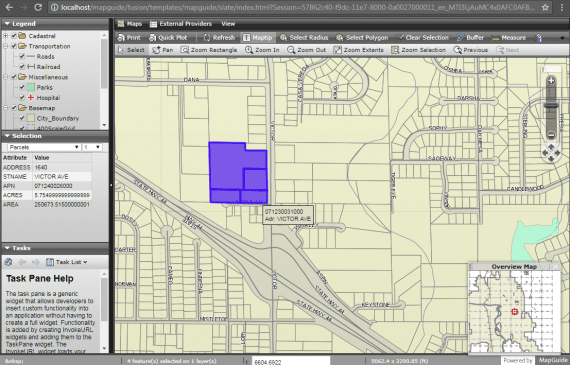
Interactive Map Viewing
- Offers a basic "AJAX" viewer
- Or an advanced "Fusion" flexible viewer with more out-of-the-box functionality and customizable viewer templates
- Or, you can roll your own viewer easily with OpenLayers
- Allows feature selection by point, rectangle, radius, or polygon with immediate feedback
- Displays feature properties in multi-line tool tips
- Displays properties of the selected feature in a property browser panel
- Supports built-in tools for spatial analysis, such as buffering, measuring and querying features within selected polygons
- Provides printing and plotting support
-
Quality Cartographic Output
- Scale-dependent detail
- Rule-driven thematic layer stylization
- Dynamic labeling with overpost detection, labels that follow the path of a line, and automatic label resizing
- Anti-aliased image rendering
- True color support
- TrueType font support
-
Built-in Resource Database for Manageability
- Provides hierarchical storage of XML resource documents that define maps, layers, data connections, symbology, and viewer layout
- Allows you to define data sources and layers once and then reference them from multiple maps for maximum reusability
- Provides an access-based security model with inheritable permissions
- Permits metadata and binary data to be associated with resource documents
-
Uniform Data Access
- Exclusive use of the Feature Data Objects (FDO) API for vector and raster feature data access
- Support for ESRI SHP, SDF and SQLite vector file formats
- Support for Oracle, SQL Server Spatial, MySQL, PostGIS and ODBC database formats
- Support for additional Raster file formats via FDO Provider for GDAL
- Support for additional vector file formats via FDO Provider for OGR
- Support for OGC WMS and WFS
-
Extensive Server-Side APIs
- Create, query, read, and write permanent and session based XML resource documents
- Query and update feature data across all supported data sources, including spatial and attribute data, and schema discovery
- Perform coordinate reprojection and great circle distance computation
- Create, manipulate, and analyze geometry with support for common spatial predicates (touches, intersects, etc) and geometric operations (buffer, union, difference, etc)
- Produce stylized vector and raster maps and legends
- Manipulate the state of the currently viewed map and legend
-
Broad Coordinate System support
- Uses the powerful CS-Map coordinate system transformation library with support for several thousand coordinate systems
- Raster and vector data of different coordinate systems are automatically re-projected on the fly to match your map
-
Your platform, your choice
- Deploy on Windows or Linux
- Serve your MapGuide applications from Apache httpd or Microsoft IIS
- Extend your MapGuide applications with the MapGuide API available in .net, Java or PHP
Implemented Standards
- Web Feature Service (WFS)
- Web Map Service (WMS)

