 The Open Source Geospatial Foundation is built on a solid foundation of open source, and that foundation starts here with the incubation committee. The incubation committee is responsible for listing projects on our website, welcoming projects to our foundation “community project initiative”, and “incubation process” mentoring teams for full recognition as an OSGeo committee.
- All projects listed on our website are geospatial and open source, and accept contributions.
- Projects with an “OSGeo Community” badge have been recognized as part of our community.
- Projects with an “OSGeo Project” badge have taken part in an extensive “incubation process,” including a code-base audit and some assurances around their long-term health and viability.
Please visit our wiki page to learn more about the incubation committee and check the status of projects taking part in our incubation program. The best way to contact us is via the OSGeo Incubation Committee Mailing List.
How to list your project on the OSGeo website?
The OSGeo website is proud to promote a wide range of geospatial open source software.
Project requirements:
- geospatial
- open source license
- accepts contributions
Website listing benefits:
- Included in a list of projects providing a reference of open source spatial projects.
- Discoverable via our choose-a-project wizard for new users.
Please contact us to be listed and promote your project team!
- Add a project (Step by step instructions)
- Checklist (wiki)
How to join the OSGeo Community Initiative?
 Our “OSGeo community” initiative is focused on innovation and outreach assisting development teams that would like to join the Open Source GeoSpatial Foundation.
Before you start:
- List your project on the OSGeo website (see above)
Project requirements:
- geospatial, user documentation
- open source license, with source code check of headers
- accepts contributions, review and acceptance of contributions
- code of conduct
OSGeo community benefits:
- Increased visibility on osgeo.org website from the drop-down projects menu.
- Developers gain confidence that they have met the OSGeo standards for not only open source, but being open for community contributions.
- Project members benefit from becoming part of a much larger community of open source software advocates interested in GIS.
- Increased visibility and outreach opportunities through better website placement, and promotion at OSGeo events, and “OSGeo community” branding.
Please contact us – we would love to welcome you to the OSGeo family!
- Checklist (wiki)
How to join the mentorship program to be recognized as an OSGeo project?

We also offer an “incubation” program for our community project teams willing to take their open source to the next level! Incubation provides each project team an experienced open source community lead to act as mentor. Projects have an opportunity to review all aspects of their codebase, software development process, communication, and transparency.
Project requirements:
- geospatial
- open source license
- accepts contributions
- source code check, with source code audit
- open community with transparent communication and decision making process
- active and healthy community with user and developer collaboration, drawing members from several organizations for long term viability
- development supported by version control and issue tracker
- developer leadership offering both transparent decision making and an opportunity for new members to participate
- user documentation and developer documentation
- release procedure covering both the release process and documented testing process
OSGeo project benefits:
- Developers and users gain confidence that it has met the OSGeo standards for professional governance and development.
- Project members benefit from becoming part of a much larger community of open source software advocates interested in GIS.
- The project is promoted as an official OSGeo project, offering users the assurance that your project is well managed.
- Each OSGeo Project is recognized as part of the OSGeo foundation, with some liability insurance for your project team, and access to OSGeo donations and annual budget.
OSGeo Projects are recognized as the foundation of our community. Please join us in building an open source future!
- Incubation process (wiki)
- Project Graduation Checklist ( pdf | markdown )
Factors OSGeo considers when evaluating a project
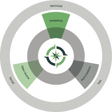
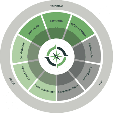
The Open Source Geospatial foundation requires more than use of an open-source software license. OSGeo asks that a project team demonstrate:
- Technical: In addition to the base requirement to be geospatial, or of interest to our geospatial community, we celebrate projects that maintain a high degree of technical excellence with end-user documentation and a document release process.
- Social: The use of an open source license (open source initiative approved) establishes a license allowing public use of technology, beyond this we expect projects to engage with their community demonstrating collaboration and open communication.
- Fair: Projects cannot realize the benefits of open source without accepting contributions, we except contributions to be treated in a fair and consistent fashion (often as outlined in a developers guide). Contributors should also be treated fairly (no description or prejudice) and protected with a code of conduct. Ideally contributors should be respected on equal terms with an avenue to join the leadership team. This same principle applies to organizations with the best projects being sustained by a diverse collaboration of organizations.
These principles have been established over our time and experience as an open source community, we believe these ideals help open source projects succeed. Our priorities are risk adverse, offering our community guidance on using open source safely and responsibly.
| OSGeo Community | OSGeo Project |
|---|---|
 |
 |
We are sensitive to some of the edge-cases around the use of open source:
- Projects that use an open-source software license, but require a data license (in effect “on ramp to commercial services”). While this is an example of publishing technology as open source, but are not in the spirit of “open” we are seeking to promote. Specifically, these projects restrict or hide the functionality of the provided code based on software or services not under your control.
- Projects that are open-source in license but do not have any developers (in effect “dumped on the internet”) may be published as open source, but are not in the sprit of “fair” we are seeking to promote. Specifically these projects lack any form of governance enabling contributions to be made.
OSGeo respects projects that have chosen to go beyond an “open source” starting point and embrace “free software” ideals. While not required for participation we recognize this level of commitment and offer “free software” projects our full support.


