CoastalME

CoastalME (Coastal Modeling Environment) is a free, open-source software designed to help understand how coastlines change over time. It’s especially useful for scientists, engineers, and planners working on coastal erosion, sediment movement, and climate adaptation.
This tool allows planners to simulate different scenarios to explore how different coastal features—like cliffs, beaches, and platforms—interact with each other and with human-made structures such as sea walls or groynes.
CoastalME starts with two main inputs:
- A digital terrain model (DTM) of the coastal area, which is like a 3D map showing the shape and elevation of the land and seafloor.
- Drivers of change, such as sea level rise, wave energy, or human interventions (e.g. sea walls or beach nourishment).
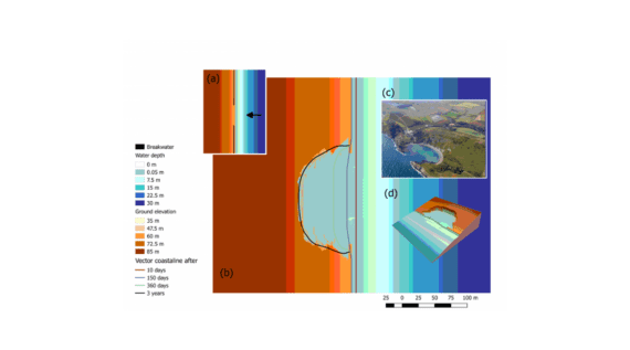
Using these inputs, CoastalME simulates how the coastline evolves over time. It applies scientific principles like mass conservation (ensuring sediment is neither created nor destroyed) and morphodynamics (how landforms change due to water and sediment movement).
The output is an updated terrain model that shows how the coastal landscape might look in the future—helping planners visualize erosion, flooding, or the effects of different management strategies.
CoastalME is also a powerful tool for researchers and engineers who want to explore how different coastal landforms—like cliffs, beaches, and estuaries—interact over time. It allows users to experiment with various modeling approaches to simulate these interactions under changing environmental conditions or human interventions.
System modellers can customize how the software represents physical processes, test different combinations of landform behaviors, and refine the rules that govern sediment movement and landscape evolution. This flexibility makes CoastalME ideal for developing new scientific insights and improving coastal management strategies.
In their 2017 study, Payo et al. explained the thinking behind CoastalME and showed how it can combine several specialized models:
- SCAPE: for soft cliff erosion
- COVE: for shoreline shape changes
- CSHORE: for wave and sediment movement across the shore
CoastalME is built using the C++ programming language and follows modern software design principles. Its code is well-documented using Doxygen, making it easier for developers to understand and contribute.
You can download the source code under the GNU open-source license and start exploring or customizing it for your own coastal modeling needs.

